

“Water is the lifeblood of the West,” says Erin Whorton, a Hydrologist working for USDA’s Natural Resources Conservation Service in Idaho. She works within the Snow Survey and Water Supply Forecasting (SSWSF) Program, which provides mountain snowpack and precipitation data that farmers and ranchers rely on to make critical decisions about their operations. Erin loves working in a scientific field that has tangible results that are immediately impactful to people’s lives. In this edition of Ask the Expert, Erin walks us through the SSWSF Program.
What is the Snow Survey and Water Supply Forecasting Program, and how does it support farmers and ranchers?
The SSWSF Program measures snowpack, precipitation, and other environmental conditions across the western United States and Alaska, and we use the data to forecast how much snowmelt runoff will be available in the upcoming irrigation season for agricultural producers.
The West relies on the mountain snowpack for its water supply. While lakes and man-made reservoirs can hold a small fraction of the water needed each year, the mountain snowpack acts like a natural reservoir that slowly melts and provides water during the drier spring and summer months. In Idaho, for example, the mountain snowpack provides roughly 75% of the surface water. Further, according to the U.S. Geological Survey, with 99% of Idaho’s surface water withdrawals being used for agriculture, including 84% for irrigated croplands and 15% for aquaculture, knowing how much water is stored in the mountains each winter is essential for farmers and ranchers.
Our information is also vital to many partners, such as the U.S. Bureau of Reclamation and U.S. Army Corps of Engineers, who use the data to safely manage reservoir fill in the spring. These partners use the information to balance flood control and water supply needs for agriculture, municipalities, instream flows for fish, and more.
In addition, our data also helps forecast hydropower generation, ensuring enough water is available to produce electricity during peak demand months. Beyond agriculture and water operations, outdoor recreation groups make heavy use of our river flow forecasts, especially boaters planning for spring runoff.
What does it take to collect and distribute reliable snowpack and water data?
The SSWSF Program monitors the mountain snowpack at 1,254 locations in two ways. The first method is through automated SNOTEL (snow telemetry) weather stations. These stations have instruments that measure the water content in the snowpack (aka Snow Water Equivalence), snow depth, precipitation (rain, snow, sleet, hail), air temperature, and at some supersites, snowpack temperature, wind speed, solar radiation and more. The data is sent out hourly. SNOTEL station data extends back to the early 1980s, when the technology first allowed us to remotely transmit data.
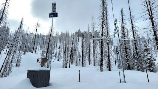
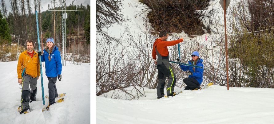
The second method is a manual approach at “snow courses,” which are long-term monitoring locations where NRCS has physically measured the snow on the first of the month throughout the winter. In some locations, data has been collected for over 100 years, before the formation of NRCS in 1935 in response to the Dust Bowl. Measurements are taken using a Federal Sampler, which is a hollow metal tube that is plunged through the snow, all the way to the ground. This allows hydrologists to measure the snow depth and extract a core of snow, which is weighed to determine the amount of water in the snowpack. Numerous NRCS employees and other volunteers collect measurements throughout the state, and SSWSF hydrologists use their insights into local conditions to ensure the collected data is as accurate and trustworthy as possible for the people who rely on it.
These snowpack measurements feed directly into our water supply forecast models, helping us answer that big question of how much water will be available each year. New AI-informed, machine-learning tools enable us to more accurately forecast streamflow at 600 sites throughout the West. This helps farmers and ranchers know what to expect and plan ahead.
What do SSWSF Program employees do in the summer?
It may seem like a snow surveyor gets to slow down in the summer, but it’s actually their busiest time of year. Each of the 900 SNOTEL sites need annual maintenance to ensure the stations are operational the following winter. SSWSF employees perform preventative maintenance, and repairs from falling trees and curious bears investigating the equipment. It takes a lot of time and effort, especially because many of these sites are in remote locations that can only be reached by ATV, helicopter, and even horses!
What should farmers and ranchers in the West know about the water supply outlook in 2026?
The West is in a “snow drought” this year, with many states experiencing their lowest snowpack on record this winter. The mid-March heat dome caused the snowpack to peak and begin melting several weeks earlier than normal. This impacts producers because their operations depend not only on the amount of water they have, but when that water is available. Without a lot of snow left in the mountains to melt and sustain streamflow levels through the spring and early summer, it’s likely producers will be forced to tap into reservoir storage or groundwater sources much earlier than normal.
The National Oceanic and Atmospheric Administration (NOAA) predicts this summer will be warmer than normal across the West which would likely increase irrigation demand and draw down reservoirs to low levels by the end of the irrigation season. This sets up producers to need a good snowpack next winter to refill reservoirs.
Learn more in NRCS’s April 21 press release, Record Low April 1 Snowpack across Western U.S. Means Impending Water Shortages.
Where can SSWSF Program data be found?
An interactive data map, water supply forecasts and reports, and more are available at www.nrcs.usda.gov/sswsf.
Kirsten Strough is a Visual Information Specialist in USDA's Farm Production and Conservation Business Center
 Loans and Grants
 Disaster Planning and Assistance
 Conservation
 Ag Business
 Farm Life